|
|
||||||||
|
|
Israel |
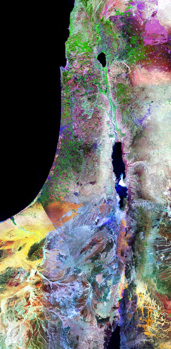 This image shows all of Israel from Mount Hermon and the Golan Heights in the north to Elat on the Gulf of Aqaba in the south, including the Sea of Galilee, the Jordan River, the Dead Sea, and portions of Lebanon, Syria, Jordan and the Sinai that surround Israel. The city of Jerusalem stands out prominently near the center of the image, with the Old City a lighter color embedded within modern Jerusalem. The streets of Tel Aviv are visible here as are the many farms and settlements that are present throughout this region. The spectacular colors of the Negev are due to differences in the mineral composition of the sand and rocks located there. The distinctive border between Egypt and Israel is a consequence of land-use differences. The Jordanian side of the Jordan River includes Amman, Mt. Nebo, Petra, and Wadi Rum. The area covered by this image is approximately 153x312 miles. A full-resolution crop of the image file is available here that shows the detail present in the full image print. Here is another crop that shows Elat at the head of the Gulf of Aqaba. Note: this is an extremely large, high-resolution image that is available in special sizes: 17x35, 24x50, 44x90. Contact me for details about pricing for this image.
|
| Copyright 2011 - Remote Sensing Art and Photographs by Larry P. Ammann, Digital Artist and Photographer. All Rights Reserved. No image or photograph may be reproduced without the artist's express written permission. |